National Fluids Lease Sale SystemU.S. Department of Interior | Bureau of Land Management (BLM)Create a New Oil & Gas Application (Expression of Interest)
Add Lands 1 of 2Quick Guide
This Quick Guide will provide you with step-by-step instructions on how to add lands to an Oil & Gas Application (Expression of Interest). To view previous steps in the process, visit Create a New Oil & Gas Application (Expression of Interest) - Getting Started Quick Guide.
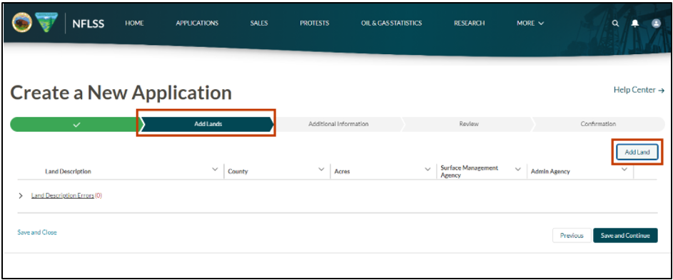
Add Lands is the second stage in the process. Select the Add Lands button.
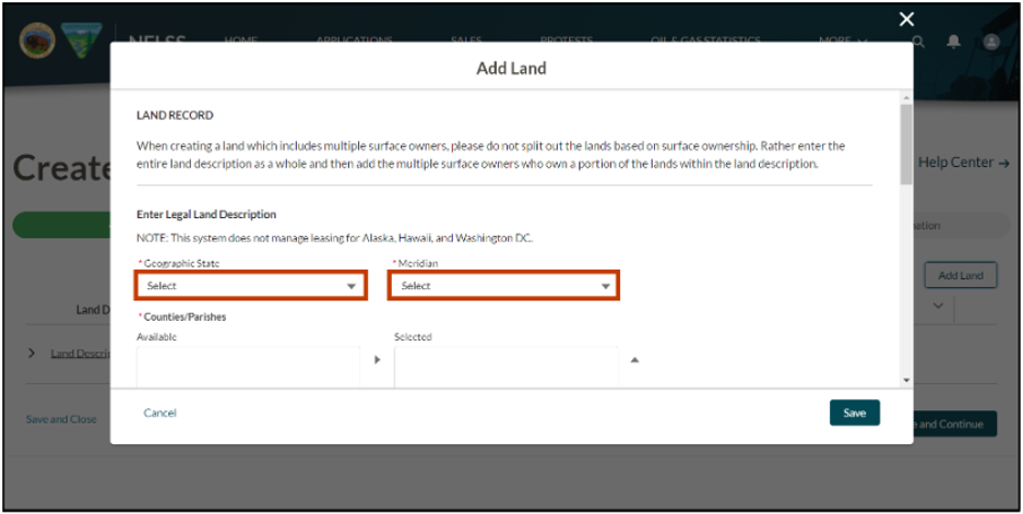
Select the Geographic State where the land is located from the dropdown. The dropdown is a dynamic list that is determined by the BLM State Office previously selected.
Select the Meridian. The meridian dropdown is a dynamic list that is determined by the Geographic State selection.
Meridian: An imaginary north-south line for public land surveys. The meridians referenced on this site are principal meridians. The meridian is a dynamic list that is determined by the Geo State selection. Geo states that do not follow the rectangular survey system (including the 13 original colonies and their territories and Texas) have a meridian represented by the states name.
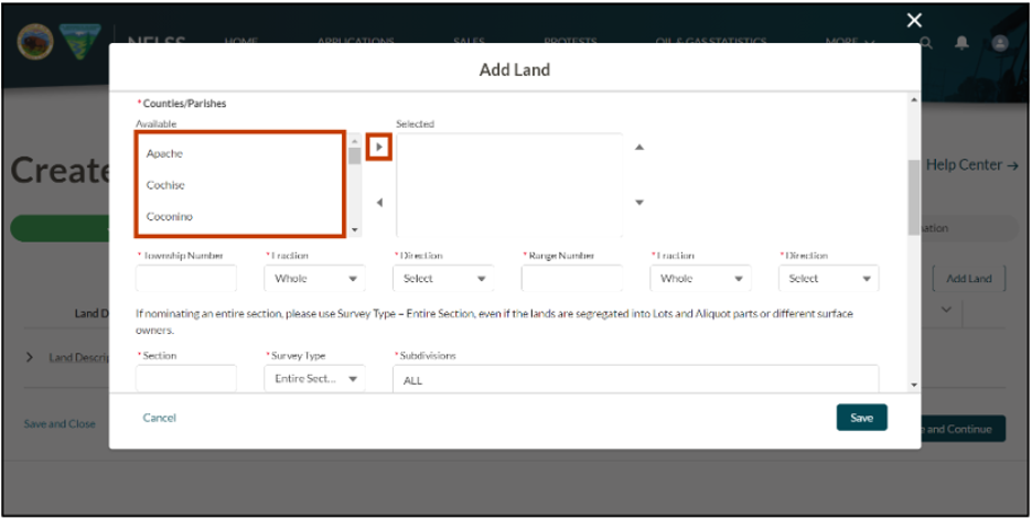
Select the County/Parish. The County/Parish field is a dynamic list that is determined by the meridian selection. Then, select the right arrow to move the county to Selected. Multiple counties can be selected by repeating this process.
If a county is mistakenly moved to the Selected list, highlight the county that was selected in error, then select the left arrow to remove the county from Selected.
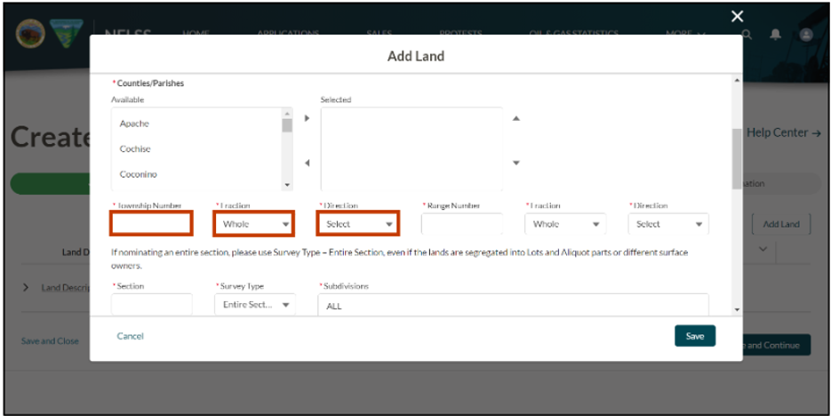
Enter the Township Number (maximum of three digits). A township is a major subdivision of the public lands under the rectangular system of surveys. It is a tract of land contained within the boundaries of the north-south range lines. Most townships are 4-sided, measuring approximately 6 miles on each side and containing approximately 36 square miles, or 23,040 acres. A township number is identified by its relation to a base line and a principal meridian. For example, "Township 5 North, Range 12 West" identifies a particular township that is 5 tiers up from the base line. In this example, the number 5 represents the Township Number. Geo states that do not follow the rectangular survey system (including the 13 original colonies and their territories and Texas) do not have a township and the Township Number is not required to be populated.
The Fraction field defaults to Whole. Fractional townships result from irregularities in the survey or the intersection of the township by the state, reservation, grant boundary, or a large body of water. If nominated lands have fractional township, select the correct fraction from the dropdown.
- Whole - Official Cadastral Township is not a fraction of a township
- 1/4 - Official Cadastral Township is only 1/4 of an entire township
- 1/2 - Official Cadastral Township is only 1/2 of an entire township
- 3/4 - Official Cadastral Township is only 3/4 of an entire township
The Direction field is the north-south direction from the dropdown. The township direction indicates which side (north or south) of the baseline the township is on. In the example, "Township 5 North, Range 12 West," North indicates the Township Direction from the (horizontal) baseline.
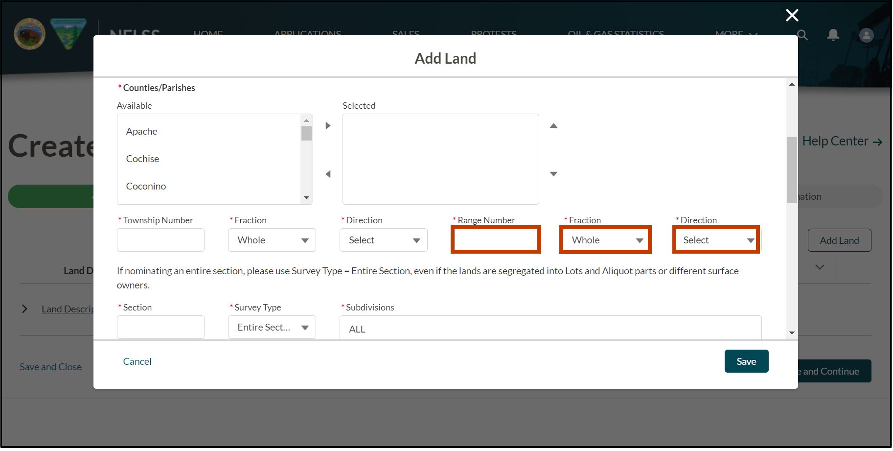
Enter the Range Number (maximum of three digits). A range is a row or tier of townships lying east or west of the principal meridian and numbered successively to the east and to the west from the principal meridian. A range number identifies a township's East or West relation to its principal meridian. In the example "Township 5 North, Range 12 West," the number 12 represents the Range Number used to identify the township that is 12 tiers to the left of the principal meridian. Geo states that do not follow the rectangular survey system (including the 13 original colonies and their territories and Texas) do not have a township and the Township Number is not required to be populated.
The Fraction field defaults to Whole. Fractional ranges result from irregularities in the survey or the intersection of the range. If nominated lands have fractional range, select the correct fraction from the dropdown.
- Whole - Official Cadastral Range is not a fraction of a range
- 1/4 - Official Cadastral Range is only 1/4 of an entire range
- 1/2 - Official Cadastral Range is only 1/2 of an entire range
- 3/4 - Official Cadastral Range is only 3/4 of an entire range
The Direction field is the east-west direction from the dropdown. The range direction indicates which side of the principal meridian the township is on. In the example "Township 5 North, Range 12 West," West indicates the direction of the township from the (vertical) meridian.
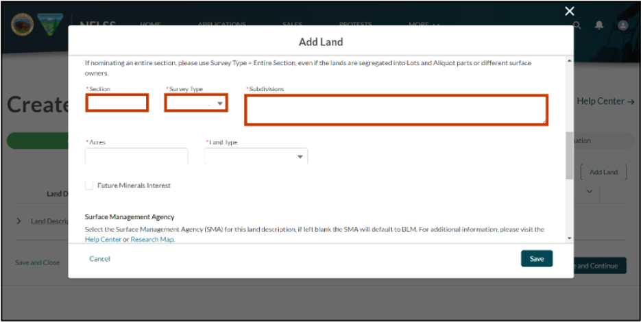
Enter the Section Number (maximum of three digits). A section is a regular tract of land, 1-mile square, containing 640 acres, within a township. It is approximately 1/36 of a township. The section number identifies a section within a township. Sections are usually numbered 1 to 36 but can be higher in some states. Alphabetic characters may be included in the section number. In some instances there are surveys with duplicate section numbers that are identified by a numeric-alpha (e.g., 12 or 12U). Geo states that do not follow the rectangular survey system (including the 13 original colonies and their territories and Texas) have a section number of 1 (or 001).
Select the Survey Type for land from the dropdown. The following survey types are available for selection:
- Aliquot: "Aliquot Parts" are a notation used by rectangular survey system to represent the exact subdivision of a section of land. Aliquot parts are described as a half or quarter of the largest subdivision of the section, except fractional lots which cannot be described by aliquot parts. Sometimes several aliquot parts are required to accurately describe a piece of land. For example, E2SW denotes the east half of the southwest quarter (containing 80 acres), and "SWNENE" denotes the southwest quarter of the northeast quarter of the northeast quarter (containing 10 acres). In general: a section contains 640 acres, a half section contains 320 acres, a quarter section contains 160 acres, a half of a quarter section contains 80 acres, and a quarter of a quarter contains 40 acres, etc.
- Lot: Fractional or odd-shaped tracts of land not generally described by conventional aliquot parts. Lotted lands generally lie on the north and west sides of a township or along meandering rivers, or bodies of water.
- Protracted: Unsurveyed lands with estimated acreages which follow the general rectangular survey system schema as displayed on the official Cadastral protraction diagram of the township.
- Tract: A standardized description of an irregularly shaped land, variable in acreage, and normally identified with a number larger than 36. Tract numbers can also be used in deeds to describe lands acquired by Federal agencies. Tracts may use a combination of numbers and letters.
- Free Form: A land description that does not fit any other survey type standard definitions such as exceptions and exclusions of land from a standardized survey type (e.g., NE excluding railroad right-of-way) or a Metes and Bounds (M&B) description (e.g., description using bearings and distances of each course).
- Entire Section: Describes the entire section even if the lands in the section have different survey types (e.g., lots and aliquot parts) or surface owners.
In the Subdivisions field, enter the land description specific to the previously selected survey type. Some survey types require specific formatting:
- Aliquot: Aliquot subdivisions must include a combination of only alpha characters N, E, S, W; the numeric value of 2 is allowable. Land descriptions of N2N2, N2S2, S2S2, S2N2, E2E2, E2W2, W2E2, W2W2 do not meet cadastral standards; therefore break into parts (e.g., N2N2 becomes N2NE, N2NW). If the description contains anything other than the allowed values, select a different survey type value.
- Lot: Only numbers are allowed. All lots separated by a comma or hyphen within a section even if they have different surface owners. Use a hyphen between 3 or more numbers in a sequence. For example, 1-3, 5, 8, 9-12, 15
- Protracted: Enter the aliquot part description or enter “ALL” if the description includes all lands within the protracted section.
- Tract: Enter in the designated tract number as displayed on the official Cadastral plat (map) or acquiring title/deed.
- Free Form: Defaults to “See Free Form Description” and cannot be changed.
-
- The Expanded Description field will appear and is a required field for this survey type. Enter a detailed description (e.g., metes and bounds description).
- Entire Section: Defaults to “All” and cannot be changed.
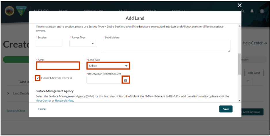
Enter the total acreage for the lands described in the Subdivision field.
Select the land type of mineral ownership, either Public Domain or Acquired, from the dropdown.
- Public Domain: Land or mineral interests in lands which never left the ownership of the United States. Lands which were obtained by the United States in exchange for public lands or for timber on such lands, and lands which have reverted to the ownership of the United States through operation of the public land laws. These minerals are leased under the Mineral Leasing Act of 1920, as amended.
- Acquired: Land or mineral interests in lands which left the ownership of the United States usually through a land patent and then acquired back into Federal ownership. These minerals are leased under the Mineral Leasing Act for Acquired Lands of 1947, as amended.
Place a checkmark in the Future Mineral Interest box if the acquired lands contain a clause about the mineral ownership transferring to the United States on a future date. The United States interest is a future interest until such reservation terminates, allowing title to vest in the United States. If the Future Mineral Interest box is checked, the Reservation Expiration Date field appears. Use the calendar icon to select the date the mineral ownership transfers to the United States.
To view the next steps in the process, visit Create a New Oil & Gas Application (Expression of Interest) - Add Lands 2 of 2 Quick Guide.
Contact the BLM Public Help Desk with any additional questions.